
Recreational boat grounding at the head of Lake Pepin, downstream of Lighthouse Island (top) and Bay City flats (bottom). Both photos are from June 2020.
In a year defined by lows, Lake Pepin water level is no exception. This year’s drop in water level is somewhat dramatic because it comes on the heels of last year’s record high water, which together, illuminates the sedimentation problem in Lake Pepin. High water pushes sediment to the lake and low water uncovers it, along with a slew of transportation issues. The Lake Pepin Legacy Alliance (LPLA) responded to recent boat groundings by visiting affected areas and discussing channel maintenance with the Army Corps of Engineers (ACOE).
Normal-to-low water levels combined with sediment build-up is the perfect recipe for recreational boat groundings at the head of Lake Pepin, especially the Bay City flats and just downstream of Lighthouse Island near Wacouta Bay. Most recreational boaters are able push themselves free after getting in the water or attracting assistance from nearby boaters. Fortunately, broken boat propellers are the only injuries we’ve heard about this year.
The major boat grounding areas are visually deceiving, especially for unfamiliar boaters headed upstream. The navigation channel hugs the Minnesota shoreline along a stretch of wide-open water that looks deep, but in actuality, only has one or two feet of depth during low water.
When LPLA investigated these areas on June 19th, we walked downstream of Lighthouse Island for hundreds of yards without the water ever passing our knees. When kayaking upstream to the Bay City flats, we were forced to walk one of our kayaks and eventually turn back due to shallow water. On our way home, we witnessed two different boat groundings downstream of Lighthouse Island where we started.

Graphs downloaded from USGS (click here).

Spring rainfall throughout much of the region was lower than normal, and much lower than 2020. As a result, Lake Pepin water levels dropped below most people’s expectations for part of June. Images downloaded from NOAA’s National Weather Service Advance Hydrologic Prediction Service (click here).
*The Median Daily Statistic is automatically calculated by USGS based on all approved discharge rates at this water gauge. For this particular gauge, only five years of data have been approved (1996, 1997, 1998, 2016, & 2017). As such, these graphs should only be interpreted as a general indicator of how recent discharge compares to any historical “normal”. The USGS Water Watch allows you to explore all provisional discharge data: Red Wing Gauge or Prescott Gauge
LPLA Board President, Abra Hovgaard, walks downstream of Lighthouse Island at the head of Lake Pepin. Both photos are taken during the same visit on June 19th, 2020, but are shown to illustrate the distance walked.
LPLA tried to kayak to the Bay City campground on June 19th, but was forced to turn around after shallow water forced one our kayaks to require walking much of the attempt.
The navigation channel is dredged to keep commerce moving, but barges are not immune to groundings. On June 8th, around 10:30 am, a barge slipped outside the navigation channel and grounded hard enough to break wires on the tow. The barge was left stranded until a new tow could arrive. After building momentum by jostling back and forth, the new tow was able to free the barge and continue downstream around 9:30 pm.
Timelapse video of the barge grounding at the head of Lake Pepin on June 8th, 2020.
LPLA Executive Director, Rylee Hince, reached out to Channels and Harbors Chief for the ACOE St. Paul District, Steve Tapp, to get more information about barge groundings and channel maintenance on the river this year. According to Tapp, all captains are required to notify the U.S. Coast Guard (USCG) anytime a commercial boat, barge, or tow touches ground inside or outside the navigation channel. They are also asked to notify the local Lock and Dam to keep the ACOE updated on local issues.
Possible barge grounding on June 12, 2020. LPLA Board President, Abra Hovgaard, observed that the barge appeared to get stuck and then jostle back and forth for several minutes before freeing itself to move upstream. The ACOE did not have a report of this incident.
The ACOE considers any situation that involves a commercial vessel touching ground as an official grounding but classifies them into three categories of increasing concern: 1) Complaint Groundings refer to situations when a vessel touches ground but can continue moving through an area; 2) Non-Critical Groundings occur when a vessel is stuck, but not blocking traffic; and 3) Critical Groundings refer to situations when a vessel is both stuck and blocking traffic.
The barge grounding on June 8th was considered, “a non-critical grounding from the channel maintenance perspective because it did not block traffic,” says Steve Tapp. He went on to explain that unfamiliarity with the area combined with a narrow channel were the main contributing factors.
Last year’s extended high water moved a lot of sediment and caused problems for the ACOE’s channel maintenance program. Sediment filled the navigation channel and, in some places, caused it to migrate significantly. According to Dan Cottrell, ACOE Dredging Manager, there hasn’t been significant channel migration in Lake Pepin in recent years, but a number of other locations in the river have had to be dredged three times in order to keep traffic moving until ice up.
Steve Tapp described this year’s overall channel conditions as “better than last year. [The ACOE] covered a lot of area last year and were able to use some of the emergency dredging fund to help address needs.”
That said, the navigation channel at the head of Lake Pepin hasn’t been dredged since 2000. Last fall, the ACOE communicated to LPLA that roughly 91,857 cubic yards of material needed to be dredged from this area, but that placement sites were not available at the time, and other locations took priority.
As long as commercial and recreational boaters stay in the channel, however, they should be safe from running aground. The main concern is that the channel is narrow with little room for error—there is a steep and sudden depth change between the channel and the shallow surroundings it runs though. It is marked with red and green buoys, but it is important to stay vigilant, either by using GPS or keeping an eye on the depth finder, because barges sometimes pull the buoys out of place.
Timelapse video of the USCG working on the Wyaconda Buoy Tender. Credit: Andre Myers.
The USCG Buoy Tender “Wyaconda” repositions the channel buoys 3-6x every year. On July 8th, the “Wyaconda” was in Pool 8 working its way upstream to Lake Pepin. To maximize efficiency, the buoy tender will do an entire ACOE district at a time and does not usually respond to complaints about individual buoys.
LPLA formed because Lake Pepin and the Mississippi River are more than just a shipping channel. As sediment accumulates in Lake Pepin at rates 10x above baseline, the only area scheduled for routine dredging is the navigation channel. For the rest of the lake, LPLA has identified other agency programs that incorporate dredging as a component of habitat improvement projects. We championed a project with ACOE and the Wisconsin Department of Natural Resources (WDNR) that is expected to increase water quality and habitat for fish and birds near Bay City, WI. Throughout the planning process, we’ve advocated that ancillary benefits to improve recreational access be incorporated wherever possible. (Read More: Lake Pepin Restoration)
Unfortunately, the area just downstream of Lighthouse Island doesn't qualify for channel maintenance dredging and isn’t a priority area for ecological improvements. As it continues to grow, Lighthouse Island serves as a powerful call to action to reduce upstream erosion and advocate for local projects that build resiliency to sediment impacts throughout the lake.
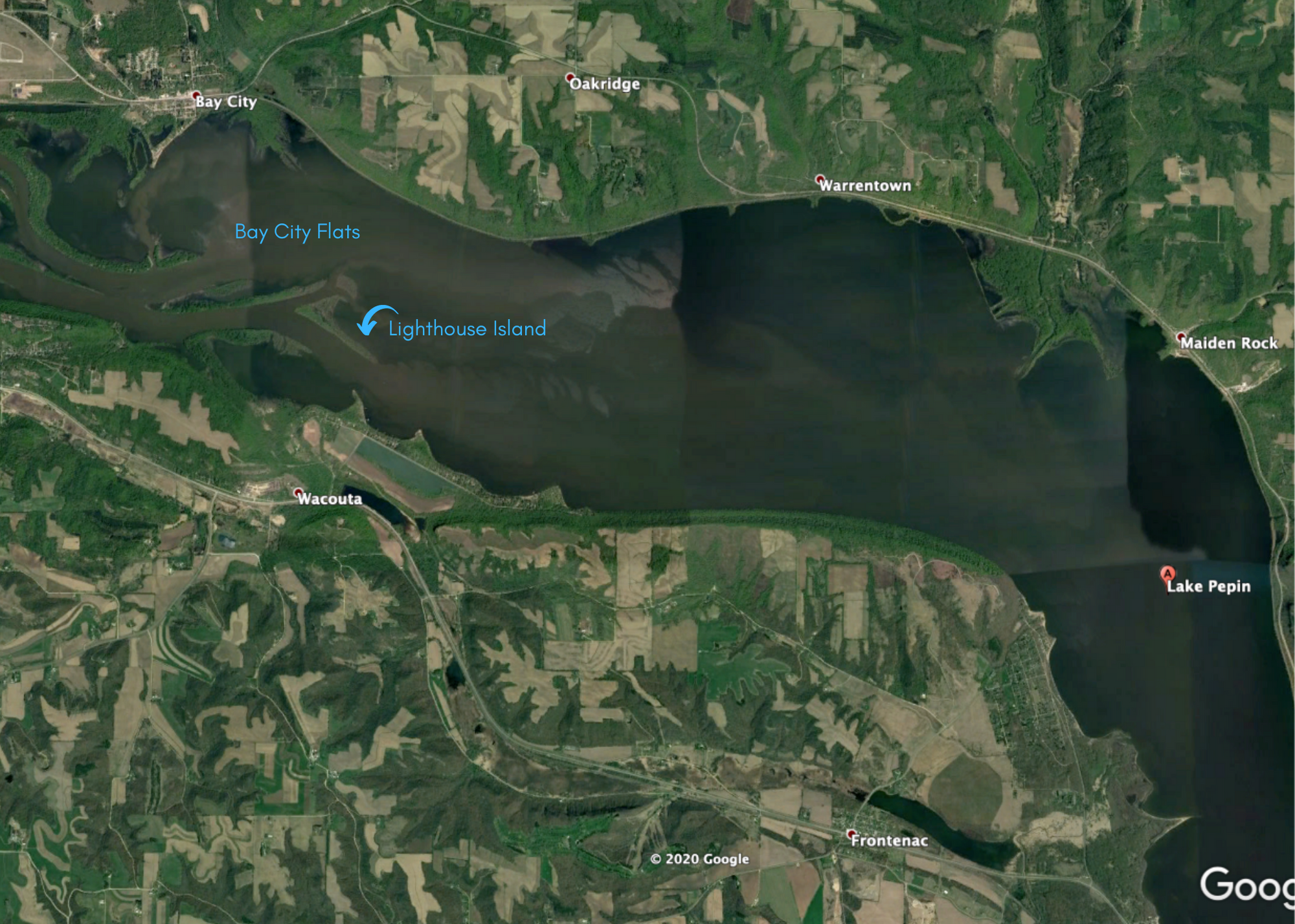
Google Earth image from 5/14/2018 shows sediment plumes flowing into Lake Pepin, where a widening of the Mississippi River allows the flow to slow and sediment to settle out and accumulate. The entire area around the Bay City Flats and downstream of Lighthouse Island are where many recreational boaters run aground. The commercial navigation channel hugs the Minnesota shoreline.